
Nation in Motion: Relational Spaces of Modern Armenia Since the 19th Century
The goal of this project, completed in February 2020 under the title Nation in Motion: Relational Spaces of Modern Armenia Since the 19th Century, was to map the origins of populations in the settlements of modern Armenia and analyze the dynamics of population migration, resettlement, and displacement resulting from major historical events.
The dataset compiled for the project encompasses population movements since the 19th century, addressing significant events such as the Russo-Turkish War, the Armenian Genocide, Soviet-era resettlements, repatriation to the Armenian SSR, and the First Karabakh War.
Utilizing this dataset, I developed an interactive map using Tableau, which is available to explore [here].
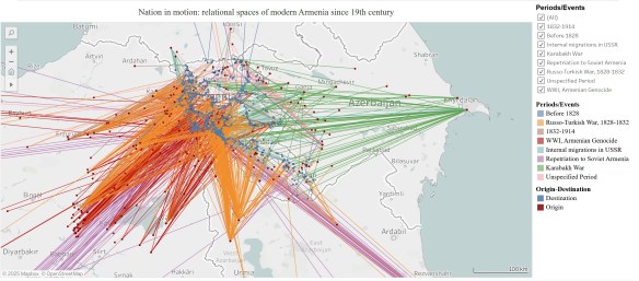
The map’s filter view, categorized by historical periods and events, facilitates a deeper understanding of population flows into modern Armenia’s territory during various historical contexts.

The dataset, its scope, limitations, and sources are available under the CC-BY-4.0 license on Open Science Framework [here].
The dataset as well as the interactive map have not been updated since February 2020.
